Typhoon Jangmi's Massive Eye Captured in Stunning Nighttime Satellite Images Near Japan
Typhoon Jangmi churned toward southern Japan with powerful winds and heavy rain, revealing a remarkably large eye visible from space.
Typhoon Jangmi Closes In on Southern Japan
Typhoon Jangmi carved a slow but menacing path north-northwest across the Philippine Sea, targeting southern Japan with sustained heavy rainfall, powerful winds, and a visually striking structure that caught the attention of meteorologists and satellite observers alike. The storm's gradual movement amplified concerns about prolonged downpours and potential flooding across multiple regions of Japan as it made its approach from late May into early June 2026.
The typhoon's sprawling rainbands stretched far beyond its center, delivering intense precipitation across a wide geographic area well before the storm's core came close to land.
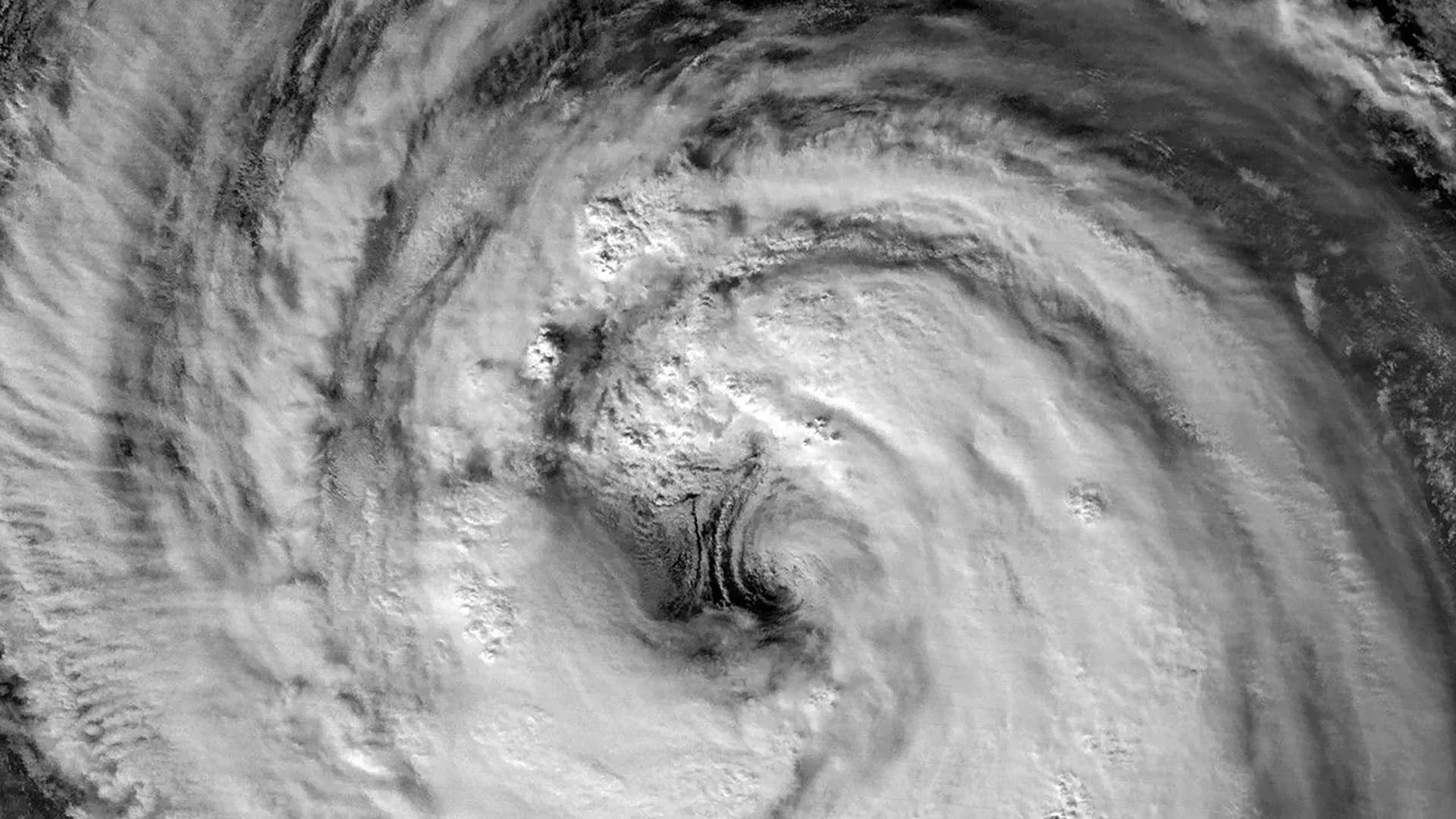
Nighttime Satellite Images Reveal a Striking Giant Eye
One of the most compelling aspects of Typhoon Jangmi was its appearance in nighttime imagery captured from orbit. The VIIRS (Visible Infrared Imaging Radiometer Suite) instrument aboard the Suomi NPP satellite recorded a detailed image of the storm on May 30 at approximately 16:40 Universal Time — equivalent to 1:40 a.m. Japan Standard Time on May 31.
At that moment, the Joint Typhoon Warning Center (JTWC) recorded sustained winds of 120 kilometers (75 miles) per hour, based on one-minute averages. That wind speed places Jangmi in a category comparable to a Category 1 hurricane on the Saffir-Simpson hurricane wind scale.
The satellite view offered an unusually clear look at the storm's eye and the eyewall encircling it. Scott Braun, a research meteorologist at NASA's Goddard Space Flight Center, noted that Jangmi's eye was notably large relative to most tropical cyclones of similar intensity.
Mesocyclones Add to the Storm's Complex Structure
The same nighttime image also revealed what appear to be low-level rotating features along the eastern edge of the eye. These formations, referred to as mesocyclones, were partially obscured beneath higher cloud layers but remained distinguishable in the satellite data. Braun explained that while these swirling structures are visually dramatic, they represent normal characteristics found within storms of this category and do not signal anything anomalous about Jangmi's behavior.
Storm Continues to Intensify as It Tracks Northward
A follow-up satellite image, captured one day later by the VIIRS instrument aboard the NOAA-20 satellite, provided a broader view of the typhoon's structure and extent. This image was acquired at roughly 16:40 Universal Time on May 31, corresponding to 1:40 a.m. Japan Standard Time on June 1.
By this point, Jangmi had gained additional strength, with sustained winds climbing to 130 kilometers (80 miles) per hour. The storm's center remained positioned south of Okinawa in both satellite views, yet its expansive outer cloud bands had already extended over portions of Japan, bringing early impacts to areas still far from the eye.
Flooding Risks Grow Along Japan's Pacific Coastline
Forecasters projected that Typhoon Jangmi would pass in close proximity to Okinawa before pivoting northeast toward the Amami region around June 1 to 2. Meteorologists warned that the storm was expected to continue generating substantial rainfall, with Japan's Pacific coastline facing the greatest risk of significant flooding and sustained downpours.
The combination of Jangmi's slow forward speed and large physical size made it a particularly concerning system, as slower storms tend to deposit greater volumes of rain over any given area before moving on. Authorities and residents in affected regions were urged to monitor official forecasts and prepare for potentially hazardous conditions.
Satellite imagery for this report was produced by Michala Garrison using VIIRS day-night band data from NASA EOSDIS LANCE, GIBS/Worldview, and the Joint Polar Satellite System (JPSS). Original reporting by Kathryn Hansen, NASA Earth Observatory.