Beneath the Grand Canyon: The Secret Water Network Keeping the Park Alive
Scientists are mapping hidden cave systems beneath the Grand Canyon to understand how snowmelt becomes the water millions of visitors and ecosystems depend on.
The Hidden Lifeline Beneath One of America's Greatest Wonders
Every time a hiker refills a water bottle at the Grand Canyon — whether standing breathless on the rim or recovering from the punishing heat deep within the canyon — they are drawing from a single, remarkable source. That source is not a river or a reservoir. It is Roaring Springs, a cave-fed spring tucked into the North Rim that quietly sustains the entire park.
Now, a team of scientists is venturing deep underground to unravel the mystery of how that water gets there — and to protect it from the growing threats of drought, contamination, and a warming climate.
A Single Spring That Powers an Entire Park
Roaring Springs supplies water to every visitor, plant, and animal within Grand Canyon National Park. Accessible only as a distant sight or sound from the North Kaibab Trail, the spring sits at the heart of a vast, invisible plumbing system hidden within the canyon's geology. As the American Southwest grows hotter and drier each decade, safeguarding this resource has shifted from a scientific curiosity to an urgent priority.
Researchers at Northern Arizona University's School of Informatics, Computing, and Cyber Systems have launched a major effort to map and understand the underground systems that feed Roaring Springs and other cave-fed springs throughout the canyon. The work, now supported by a dedicated grant from Grand Canyon National Park, builds on early findings recently published in Scientific Reports.
Mapping the Unmappable: Inside the Canyon's Hidden Caves
The caves that feed the Grand Canyon's springs are closed to the public and often located far off any established trail. Until recently, much of what scientists understood about these systems was based on limited data and educated inference.
That is beginning to change.
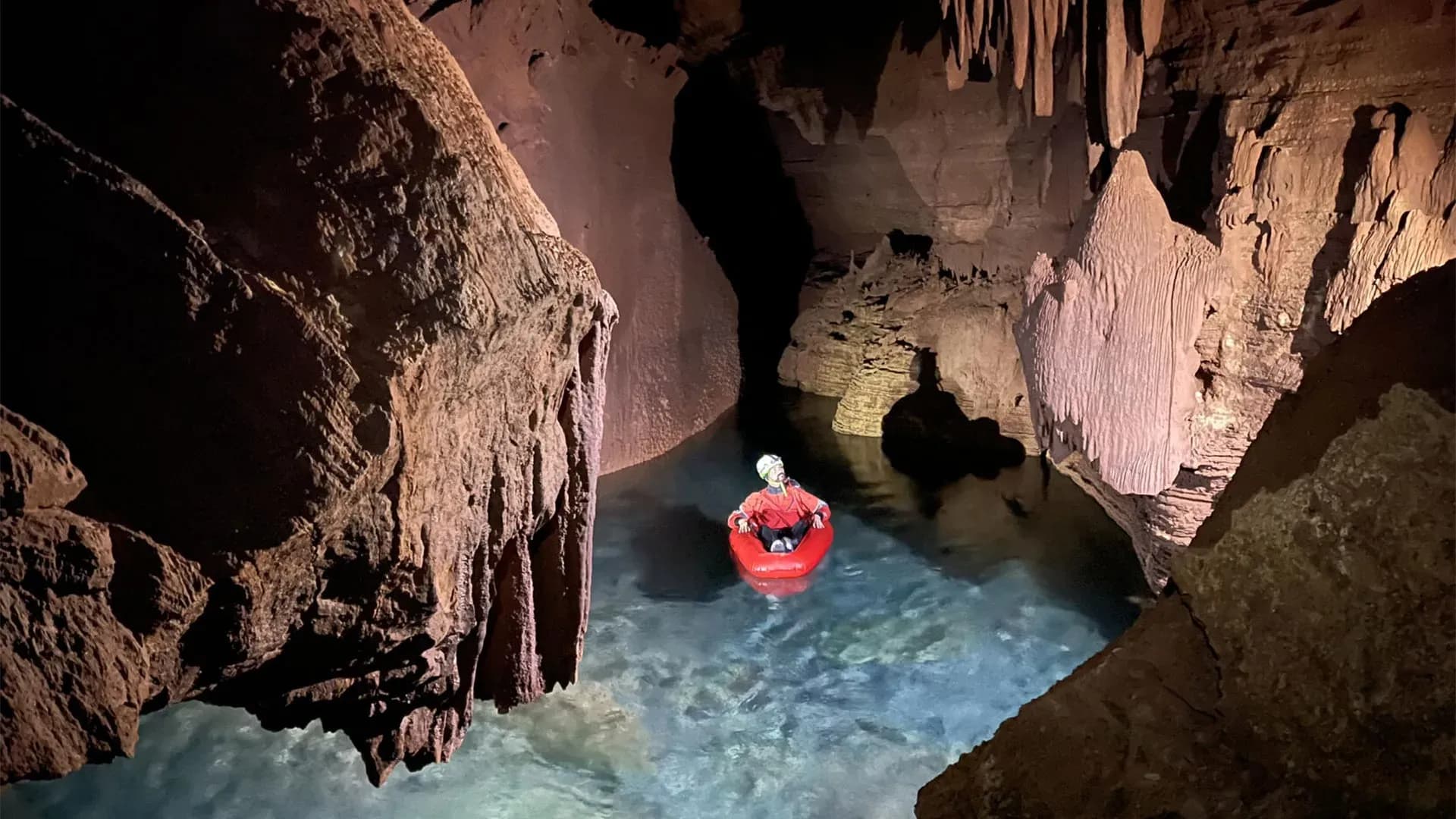
Ph.D. student Blase LaSala, working alongside remote sensing expert and professor Temuulen "Teki" Sankey, used a mobile lidar scanner to build detailed, high-resolution three-dimensional models of several cave systems beneath the canyon. Over 45 days of fieldwork, the team — including researchers, volunteers, and park staff — documented more than 10 kilometers of underground passages, chambers, and corridors.
"I had no idea how large and long these caves are," Sankey said. "We have been able to produce really high-resolution 3D maps, which, from a remote sensing perspective, is what's unique and novel about it. Grand Canyon's caves have never been mapped in 3D like this."
The Physical Challenge of Underground Science
The work was anything but straightforward. Team members hauled packs weighing up to 55 pounds through remote terrain, sometimes requiring two full days of hiking just to reach a cave entrance. Once inside, they climbed, rappelled, crawled through tight passages, and in some cases floated through flooded sections — all while carefully recording the caves' structural geometry and fracture patterns.
Those fracture patterns matter enormously. Cave architecture follows predictable geological logic, and the arrangement of cracks, passages, and openings tells scientists how water might be traveling through the rock layers far beneath the surface.
Tracing Water Through a Geological Black Box
The basic origin of the water is relatively straightforward: snowmelt from the Kaibab Plateau. But how that water travels through hundreds or thousands of feet of rock before emerging at a spring like Roaring Springs is far less understood.
The springs themselves sit within Redwall and Muav limestone formations — yet multiple rock layers lie between those formations and the plateau surface above. Previous dye tracing experiments have offered some striking clues. In tests conducted with collaborator and NAU professor Abe Springer, dye poured into sinkholes on the plateau traveled approximately 20 kilometers and appeared at springs in as little as one week.
The speed alone raises important questions about the nature of the underground pathways involved. Fractures, geological faults, rock permeability, and the specific geometry of underground channels all play a role in determining how water moves through the system.
"It's like looking at a black box," LaSala explained. "You see what comes in and what comes out, but it's very hard to quantify what's going on in there. Now that we know what patterns are there, we can really start to relate the data to spring change over time."
Why This Research Goes Beyond Scientific Curiosity
Understanding underground water movement is not merely an academic exercise. It carries direct consequences for public health and park operations.
The Grand Canyon's major springs are fed by karst systems — complex networks of holes, channels, and conduits that Sankey likens to "Swiss cheese." Water moves rapidly through these networks, which means there is little opportunity for natural filtration along the way.
The same speed that makes karst systems hydrologically fascinating also makes them vulnerable. Contaminants from wildfire runoff or harmful bacteria such as E. coli could enter the system through sinkholes and reach the Roaring Springs water supply within days. When contamination events occur, park officials may be forced to shut down water pumping operations entirely until the issue is resolved.
By pinpointing exactly where water enters the underground system and mapping how it travels, researchers can help park managers identify contamination sources faster and reduce the likelihood of future disruptions.
What Comes Next: A Broader View From Above
The next phase of the project is expected to begin in early 2026, expanding the research from underground caves to the surface landscape above.
Using airborne lidar surveys and decades of satellite data, LaSala and Sankey plan to map sinkholes on both sides of the canyon while analyzing snow accumulation and snowmelt patterns going back 40 years. The goal is to connect what is happening at the surface — where water enters the system — with what has been documented deep underground.
This data will also guide future dye tracing experiments and help build a comprehensive archive of environmental information that can be combined with imaging technologies to improve regional water system modeling.
A Shrinking Snowpack and a Growing Concern
Snow is a central focus of the research for a reason. Arizona has experienced a long-term decline in snowpack levels, and the Grand Canyon region reflects that broader trend. As snowmelt decreases, so too does the recharge rate of the underground systems that feed critical springs — with consequences for every living thing that depends on them.
"Understanding where the water sinks is critical for the infrastructure, the animals, the plants and the rest of the ecosystems that rely on these springs," LaSala said. "They're like oases."
A Local Problem With Global Implications
While the immediate beneficiary of this research is Grand Canyon National Park, its relevance reaches far beyond northern Arizona. More than one billion people worldwide rely on water sourced from karst springs. The methods and insights developed beneath the Grand Canyon could ultimately inform water management strategies across the globe — helping communities prepare for a future in which clean, reliable water becomes an increasingly precious resource.